
Windows Android
-
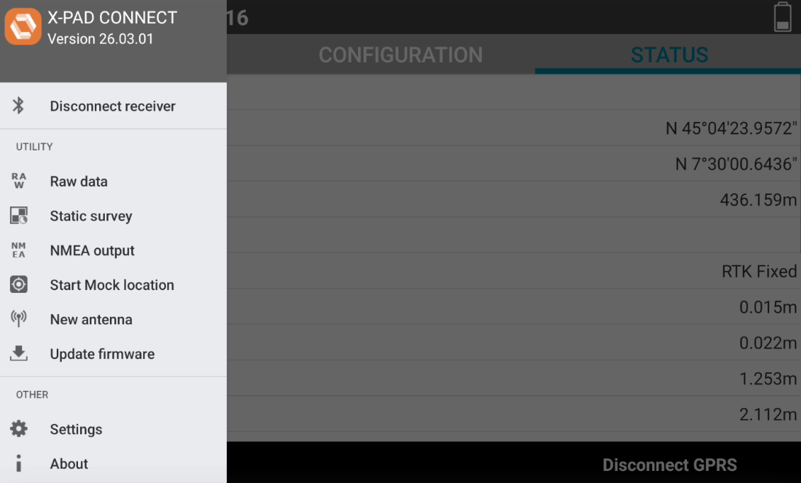
X-PAD Connect utilities are available from the software menu.
-
Android To open the list of Utilities tap on top-right icon

-
Windows X-PAD Connect utilities are available from the bottom toolbar.

-
Update firmware: starts the procedure to update GNSS receiver firmware.
-
Windows Android Raw data: accesses the GNSS receiver internal memory to download recorded raw data.
-
Android Static survey: allows to start raw data logging.
-
Windows Android NMEA output: starts the NMEA messages data output from serial port or Bluetooth to be utilized by 3th party application.
-
Android Start Mock location: a mock location is a GNSS location that replaces your device's actual physical location, allowing to use the accurate position from a GNSS receiver in third-party app. The software, when working with a GNSS receiver, allows to use the actual GNSS receiver as mock location, in order to give access to the precise coordinate to other Android applications. This utility allows to start the GNSS mock location.
-
Windows Android New antenna/Antenna: loads in Qthe GNSS receiver memory a new antenna. This operation has to be done when rover is working connected to a different brand single antenna.
-
Windows Android Update firmware/Firmware upload: starts the procedure to update GNSS receiver firmware.
-
Windows Advanced: loads on GNSS receiver the license key.
-
Raw data manager
Windows Android
-
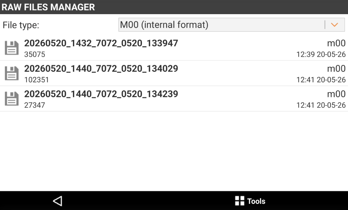
Raw files manager utility allows to manage raw data file stored in GNSS receiver memory.
-
The page lists the recorded files.
-
Tap on File type drop down list to select the file type to visualize (raw data or Rinex data).
-
Press Tools to perform different operations:
-
Delete file: deletes selected files from the memory.
-
Download files: downloads selected files from the memory to field controller. The files are downloaded in the folder Download/XPADConnect/Raw data files.
-
Share files: shares selected files using compatible 3th party Android applications available on the field controller.
-
Static survey
Android
-
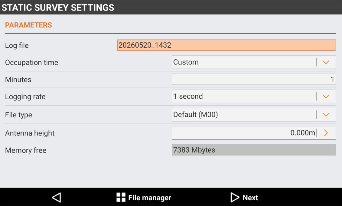
Static survey function allows to save raw data in receiver memory.
-
The Static survey settings page allows to enter the parameters for the raw data recording.
-
Log file: name of the raw data file.
-
Occupation time: allows to select the occupation time for the static survey. Select Manual to stop manually the recording, select Custom to enter a custom occupation time in Minutes, or select a predefined occupation time.
-
Logging rate: the raw data logging rate.
-
File type: selects the format of the raw data file. It is possible to select proprietary format or Rinex format.
-
Antenna height: the GNSS receiver antenna height from the reference point.
-
Memory free: visualizes the free memory of the GNSS receiver.
-
-
Press File Manager to open the Raw data manager.
-
Press Next to proceed.
-
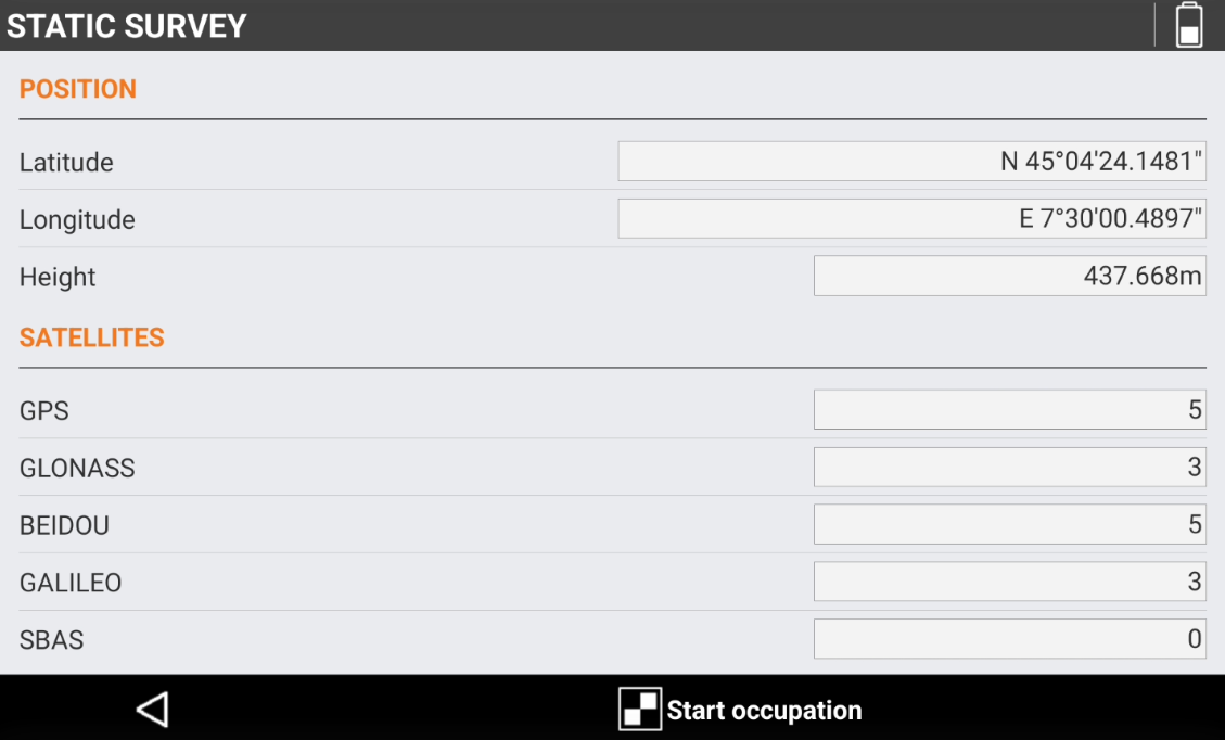
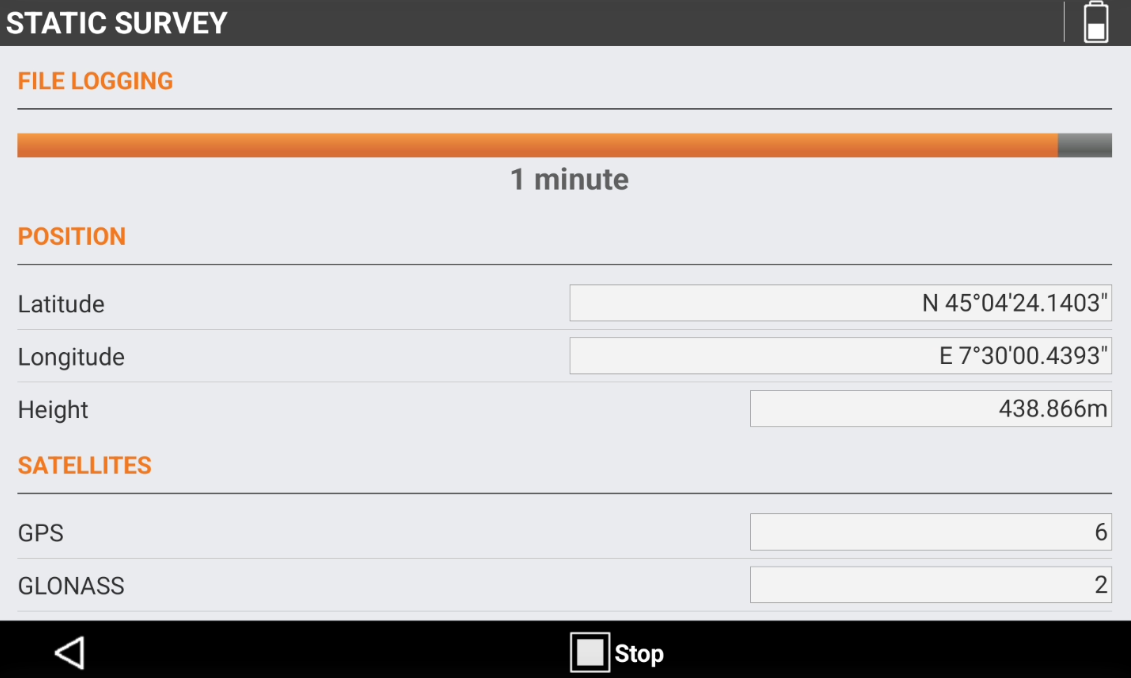
The following page displays the current GNSS receiver position and the tracked satellites.
-
Press Start occupation to start to log the raw data.
-
The top bar shows the remaining time from the configured Occupation time.
-
Press Back to interrupt the raw data logging and save the file.
-
Press Stop to interrupt the raw data logging.
NMEA output
Windows Android
-
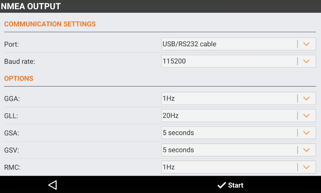
NMEA output allows to stream out different GNSS receiver information (position, quality, etc..) in the standard NMEA format to be utilized in 3th party devices.
-
Port: allows to select if the NMEA messages are streamed out using the USB/RS232 port and cable or by Bluetooth.
-
Baud rate: the communication baud rate.
-
GGA: output rate for the GGA message. The message includes time, position and fix related data.
-
GLL: output rate for the GLL message. The message includes position data: position fix, time of position fix, and status.
-
GSA: output rate for the GSA message. The message includes DOP and active satellites.
-
GSV: output rate for the GSA message. The message includes number of SVs in view, PRN, elevation, azimuth, and SNR.
-
RMC: output rate for the RMC message. The message includes position, velocity and time.
-
GST: output rate for the GST message. The message includes position error statistics.
-
ZDA: output rate for the ZDA message. The message includes UTC day, month, and year, and local time zone offset.
-
VTG: output rate for the VTG message. The message includes information on speed and direction.
-
-
Press Start to start the NMEA data streaming.
Android If Write file is enabled in Settings, the NMEA messages are also recorded in a text file.
GNSS mock position
Android
-
A mock location is a GNSS location that replaces your device's actual physical location, allowing to use the accurate position from a GNSS receiver in third-party app.
-
The software, when working with a GNSS receiver, allows to use the actual GNSS receiver as mock location, in order to give access to the precise coordinate to other Android applications.
Select X-PAD Connect as mock application
-
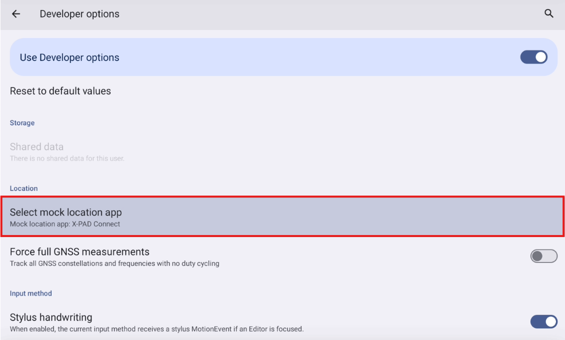
The first step is to select X-PAD Connect as mock application in Android developer options.
-
Enable the developer options in Android.
To enable the Developer options in Android, you must be a developer. In most of Android devices this is done clicking 5 times on Build number field in About tablet.
-
In Android Settings select Developer options.
-
Tap on Select mock location app and select X-PAD Connect from the list.
Start GNSS mock location from X-PAD Connect
-
The receiver has to be configured as rover.
-
Select Start Mock location from the utilities.
-
X-PAD shows the message Mock location active.
-
Do not close X- PAD software but reduce it and open the third-party app where you want to use the GNSS receiver accurate position.
-
Configure the third-party app to use the GNSS position from the device.
-
The app is using the position from the topographic instrument.
New antenna definition
Windows Android
-
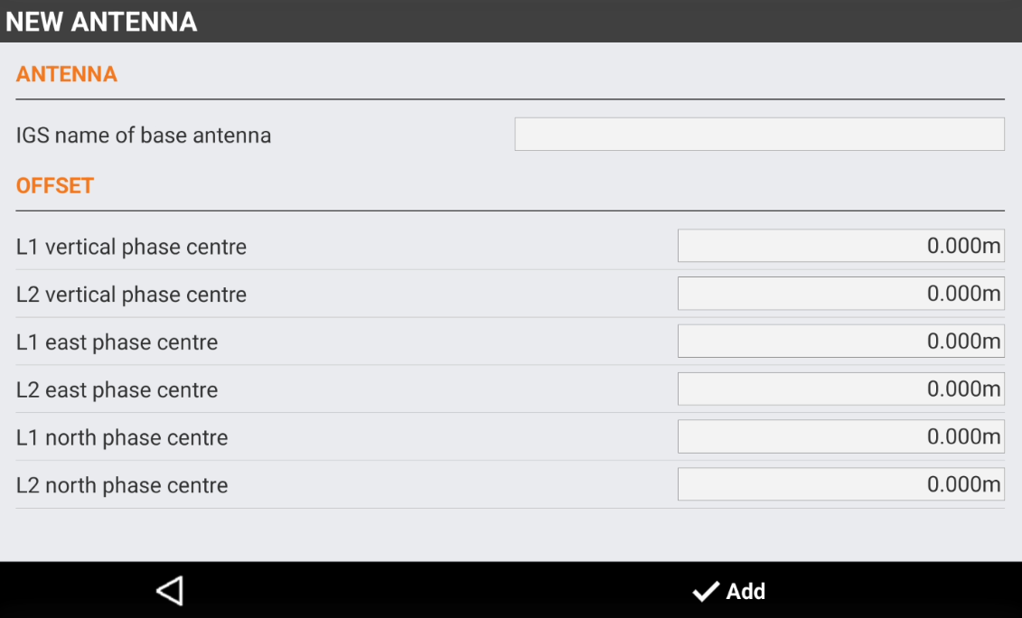
New antenna page allows to enter the definition of new GNSS antennas.
-
This function is useful when the GNSS receiver has to be connected to a local GNSS base not from Hexagon.
This is not necessary when working with reference station networks.
The information to enter in this page can be retireved for example from Antenna Calibrations
-
To create a new antenna select New antenna from the utilities.
-
IGS name of the base antenna: the IGS name of the base antenna. The IGS name includes the DOME.
-
Offset: the vertical, east and north phase center offset for L1 and L2.
-
Update firmware
Windows Android
-
The utility Update firmware can be utilized to update the firmware of the GNSS receiver.
-
The procedure is different depending on the GNSS receiver model connected to X-PAD Connect.
-
Please refer to specific GNSS receiver user manual for more information.
Load license key
Windows
-
The utility Load license key can be utilized to upload a new license key to connected GNSS receiver.
-
Please refer to specific GNSS receiver user manual for more information.
-
To upload a new license key press Advanced and select Load license key.
-
Select the key file from the PC and select OK.